When Neil Armstrong took that famous “one small step” onto the lunar surface, it was the culmination of years of technological innovation and precise navigation. But how exactly did astronauts find their way to the moon, a celestial body nearly a quarter-million miles away? Let’s embark on a journey through the fascinating world of space navigation that made the Apollo missions possible.
The Celestial GPS: Apollo’s Primary Guidance, Navigation, and Control System

At the heart of Apollo’s navigation was the Primary Guidance, Navigation, and Control System (PGNCS, pronounced “pings”)[5]. This self-contained inertial guidance system was the astronauts’ trusty companion, especially when Earth was out of sight or when communications went dark. Think of it as the ultimate backseat driver, but one you’d actually want to listen to.
The Apollo Primary Guidance, Navigation, and Control System (PGNCS)

The Brain of the Operation: Apollo Guidance Computer

The PGNCS was powered by the Apollo Guidance Computer (AGC), a marvel of 1960s technology. This computer, with less processing power than your average smartphone, was responsible for critical calculations and control of the spacecraft[4]. It was like having a really smart, really dedicated math whiz on board who never needed a coffee break.
Inertial Measurement Unit: The Spacecraft’s Inner Ear
The Inertial Measurement Unit (IMU) was the PGNCS’s way of sensing the spacecraft’s movement. Using gyroscopes and accelerometers, it could detect changes in the vehicle’s orientation and acceleration[1]. It was essentially the spacecraft’s sense of balance, minus the dizziness after spinning in circles.
Stargazing with a Purpose: Optical Navigation
While the PGNCS was impressive, even the best technology can drift off course over time. That’s where good old-fashioned stargazing came in handy.
The Space Sextant: Not Your Average Pirate Tool
Astronauts used a space sextant, an upgraded version of the tool used by sailors for centuries[2]. This device allowed them to measure angles between celestial bodies and determine their position in space. It was like playing connect-the-dots with stars, only with much higher stakes.
Alignment Optical Telescope: The Cosmic Peephole
The Command Module was equipped with a scanning telescope and a sextant for precise star sightings[4]. The Lunar Module, being the lightweight cousin, made do with a simpler alignment optical telescope[2]. These tools allowed astronauts to manually check their position and realign the guidance system if needed.
Ground Control to Major Tom: Earth-Based Navigation Support

While the onboard systems were impressive, the Apollo missions also relied heavily on ground-based tracking and navigation support.
Principle of P23 Cislunar Navigation
P23 cislunar navigation helps spacecraft find their position and velocity in space during their journey between Earth and the Moon. This is done using state vectors, six numbers that describe where the spacecraft is (position) and how fast it’s moving (velocity) in three-dimensional space.
Normally, the state vector is calculated using radio signals between the spacecraft and Earth. As a backup, astronauts can use a sextant to measure the angle between a star and the horizon of Earth or the Moon. These measurements help confirm the spacecraft’s path and ensure it reaches its destination accurately, as Apollo 11 did when entering lunar orbit.
Deep Space Network: The Cosmic Call Center
NASA’s Deep Space Network provided crucial tracking data, which was processed by computers at Mission Control[5]. This data was often more accurate than the onboard calculations, proving that sometimes it pays to phone a friend.
State Vector Updates: Cosmic GPS Recalibration
Periodically, astronauts would receive state vector updates from Mission Control based on ground tracking data[5]. These updates helped keep the onboard navigation system in sync with the more accurate Earth-based calculations. It was like getting directions from a local when your car’s GPS is on the fritz.
Navigating the Lunar Landing: The Final Descent

The lunar landing phase was perhaps the most critical and complex navigation challenge of the entire mission.
Landing Radar: Measuring the Final Stretch
As the Lunar Module descended, it used a landing radar to measure its altitude and velocity relative to the lunar surface[4]. This data was crucial for ensuring a soft landing and not creating a new lunar crater.
Manual Control: The Human Touch
Despite all the advanced technology, the final phase of landing was often controlled manually by the astronauts[4]. This human-in-the-loop approach allowed for last-minute adjustments and showcased the incredible skill of the Apollo pilots.
Conclusion: A Testament to Human Ingenuity
The navigation techniques used in the Apollo missions were a brilliant combination of cutting-edge technology and time-tested methods. From star sightings to computer calculations, from ground tracking to manual piloting, every element played a crucial role in guiding astronauts to the moon and back.
As we look to the future of space exploration, with missions to Mars and beyond on the horizon, the legacy of Apollo navigation continues to inspire and inform. The next generation of space travelers will stand on the shoulders of these cosmic pioneers, armed with even more advanced technology but guided by the same spirit of innovation and exploration.
So the next time you use your smartphone’s GPS to navigate to the nearest coffee shop, spare a thought for the astronauts who navigated to the moon with less computing power than the device in your pocket. Now, that’s what we call stellar navigation!
Citations:
[1] https://www.ion.org/publications/abstract.cfm?articleID=966
[2] https://wehackthemoon.com/tech/space-sextant-navigates-moon-missions
[3] https://www.reddit.com/r/SEO/comments/r0ww4s/am_i_required_to_write_blog_posts_as_an_seo/
[4] https://ntrs.nasa.gov/api/citations/19720063753/downloads/19720063753.pdf
[5] https://en.wikipedia.org/wiki/Apollo_PGNCS
[6] https://community.openai.com/t/best-prompt-for-seo-content-writing/264915
[7] https://repository.si.edu/bitstream/handle/10088/24973/201085SH.pdf
[8] https://app.gravitywrite.com/tools/advanced-blog-post
[9] https://web.mit.edu/digitalapollo/Documents/Chapter7/gnccoursenotes.pdf
[10] https://www.tealhq.com/cover-letter-examples/content-writer
[11] https://maphappenings.com/2024/10/03/moon/
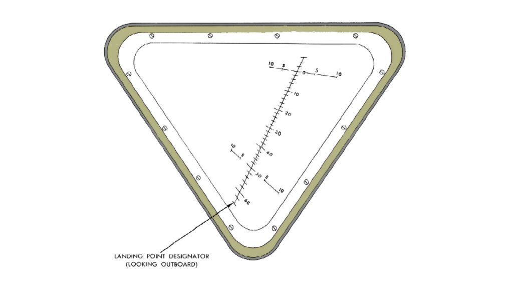
What is the Grid Pattern in the Lunar Module’s Window? Understanding the Landing Point Designator (LPD)
